Geospatial Imagery Analytics Market - Analysis and Forecast (2026–2035)
Industry Insights by Type (Video Analytics and Imagery Analytics), by Collection Medium (Satellites, Geographic Information Systems [GIS], Unmanned Aerial Vehicles [UAVS], Others), by Application (Geospatial Data Acquisition & Mapping, Surveillance & Monitoring, Disaster Management, Construction & Development, Exhibition & Live Entertainment, Energy & Resource Management, Conservation & Research), by Vertical (Agriculture & Forestry, Government, Energy & Mining, Civil Engineering & Archaeology, Defense, Healthcare & Life science, Media & Entertainment, Others) and by Geography (North America, Europe, Asia-Pacific, Middle East, and Rest of the World)
| Status : Published | Published On : Jan, 2026 | Report Code : VRICT5031 | Industry : ICT & Media | Available Format :

|
Page : 174 |
Geospatial Imagery Analytics Market - Analysis and Forecast (2026–2035)
Industry Insights by Type (Video Analytics and Imagery Analytics), by Collection Medium (Satellites, Geographic Information Systems [GIS], Unmanned Aerial Vehicles [UAVS], Others), by Application (Geospatial Data Acquisition & Mapping, Surveillance & Monitoring, Disaster Management, Construction & Development, Exhibition & Live Entertainment, Energy & Resource Management, Conservation & Research), by Vertical (Agriculture & Forestry, Government, Energy & Mining, Civil Engineering & Archaeology, Defense, Healthcare & Life science, Media & Entertainment, Others) and by Geography (North America, Europe, Asia-Pacific, Middle East, and Rest of the World)
Geospatial Imagery Analytics Market Overview
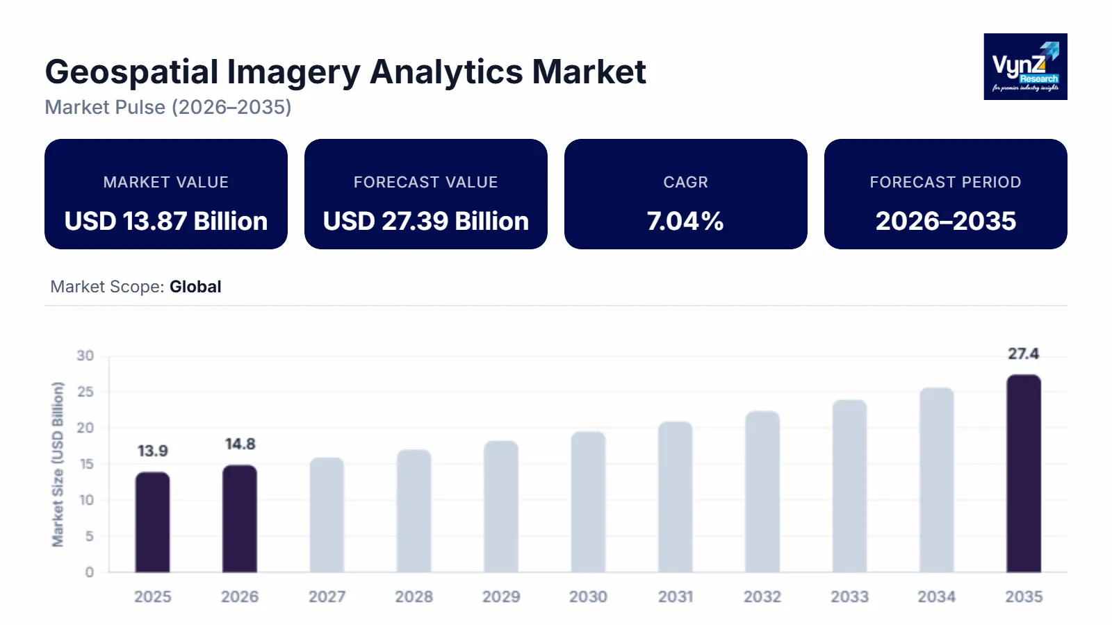
The global Geospatial Imagery Analytics Market was valued at USD 13.87 billion in 2025 and is estimated to reach around USD 14.84 billion in 2026. It is projected to reach approximately USD 27.39 billion by 2035, expanding at a CAGR of about 7.04% from 2026 to 2035. Technological upgradations and increased competitiveness among the key players operating in the geospatial imagery analytics market across the globe are propelling the growth of the market.
Market Segmentation
Type Insights
Based on type, the global geospatial imagery analytics market is categorized into video analytics and imagery analytics, wherein the video analytics category is expected to witness faster growth during the forecast period. This can be ascribed to the increasing demand for drone and satellite video surveillance across various industry domains worldwide.
Collection Medium Insights
On the basis of collection medium, the global geospatial imagery analytics market is segmented into satellites, geographic information systems (GIS), unmanned aerial vehicles (UAVs) and others. Of all, the UAVs category is expected to witness the fastest growth during the forecast period. The extensive embracement of UAVs pertaining to cost-effectiveness as compared to those developed by other collection media is the major factor fuelling the growth of this category in the market.
Application Insights
Based on application, the global geospatial imagery analytics market is categorized into geospatial data acquisition and mapping, surveillance and monitoring, disaster management, construction and development, exhibition and live entertainment, energy and resource management, and conservation and research. Of all, the surveillance and monitoring category is expected to continue holding the largest share during the forecast period, as this technology occupies extensive opportunities to business enterprises related to problem-solving and effective decision-making ability for enhancing the smooth functioning of the organization. Moreover, due to enhanced usage of this technology, the defense and military domains is rapidly adopting this technology worldwide.
Vertical Insights
Based on vertical, the global geospatial imagery analytics market can be segmented into agriculture and forestry, government, energy and mining, healthcare and lifescience, civil engineering and archaeology, defense, media and entertainment, and others. Of all, the healthcare & life sciences sector is expected to witness the fastest growth during the forecast period. The growth of this segment is attributed to swelling demand of geospatial imagery analytics solutions in the health management of people along with availing them with valuable healthcare services.
Global Geospatial Imagery Analytics Market Report Coverage
|
Report Metric |
Details |
|
Historical Period |
2020 - 2024 |
|
Base Year Considered |
2025 |
|
Forecast Period |
2026 - 2035 |
|
Market Size in 2025 |
U.S.D. 13.87 Billion |
|
Revenue Forecast in 2035 |
U.S.D. 27.39 Billion |
|
Growth Rate |
7.04% |
|
Segments Covered in the Report |
By Type, By Collection Medium, By Application, and By Vertical |
|
Report Scope |
Market Trends, Drivers, and Restraints; Revenue Estimation and Forecast; Segmentation Analysis; Companies’ Strategic Developments; Market Share Analysis of Key Players; Company Profiling |
|
Regions Covered in the Report |
North America, Europe, Asia-Pacific, Middle East, and Rest of the World |
Industry Dynamics
Market Trends
The increasing acceptance of video-based imagery is the key trend observed in the growth of the geospatial imagery analytics market across the globe. In video-based imagery, data is kept in video-recording format due to the presence of imagery analytic services. Moreover, the increasing number of nano and small satellite launches is another trend about the growth of the global geospatial imagery analytics market. Furthermore, the existence of a large number of satellites across the world implies high revisit rates and enhanced frequency of data.
Market Growth Drivers
The global geospatial imagery analytics market has been driven by several key factors, predominantly increasing acceptance of video-based imagery, technological advancements, and an increasing number of nano and small satellite launches. The latest technology, such as big data and artificial intelligence, enables various business enterprises to perform efficient and speedy analysis of data as a result, key providers are extensively assimilating these technologies for delivering vital insights in a reduced amount of time.
Technological Advancements: The rapid advancements in remote sensing technologies, satellite imagery, and aerial photography have significantly improved the quality and accessibility of geospatial data. This has enabled more accurate and detailed analysis of geospatial imagery, driving the demand for geospatial imagery analytics solutions.
Rising Adoption of UAVs and Drones: Unmanned Aerial Vehicles (UAVs) and drones are being increasingly used to capture high-resolution imagery and survey large areas quickly and cost-effectively. This has expanded the availability of geospatial imagery data, fueling the demand for analytics solutions to extract meaningful insights from the collected data.
Growing Importance of Location-Based Services: Location-based services (LBS) have become integral to various industries such as transportation, logistics, urban planning, agriculture, and natural resource management. Geospatial imagery analytics plays a crucial role in extracting location-based insights from satellite imagery and other geospatial data, enabling better decision-making and operational efficiency.
The emergence of Big Data and AI Technologies: The availability of vast amounts of geospatial data, coupled with advancements in big data analytics and artificial intelligence (AI), has opened up new possibilities for geospatial imagery analytics. AI-based algorithms and machine learning techniques can process large datasets, identify patterns, and extract actionable insights from geospatial imagery more efficiently.
Increasing Demand for Defense and Security Applications: Geospatial imagery analytics plays a critical role in defense and security applications, including intelligence gathering, border surveillance, threat detection, and emergency response. The growing need for enhanced situational awareness and real-time monitoring is driving the adoption of geospatial imagery analytics in the defense and security sector.
Moreover, it has been observed that various industries such as healthcare, banking, financial services, and insurance (BFSI), and the retail and e-commerce industry are the key beneficiaries of these evolving technologies that are helping them in extracting useful information and further classifying a large amount of data.
Market Challenges
Key factor hindering the growth of the geospatial imagery analytics market is increasing government compliance pertaining to geospatial data. The government policies comprising of geospatial data are stringent due to risk related to the breach of data and the utilization of this data for unfair means. Furthermore, integration of geospatial imagery analytics data with enterprise solutions is another factor that is expected to hamper the growth of the geospatial imagery analytics market in the near future.
Recent Developments By the Key Players
Satellite imagery firm Planet Labs has signed a $230 million agreement to build satellites for an unnamed customer in the Asia-Pacific region, clinching its biggest contract yet as the company expands beyond data services. Their first hyperspectral satellite, Tanager-1, along with 36 SuperDoves (Flock 4BE) is successfully launched into orbit during the Transporter-11 Rideshare mission with SpaceX, which lifted off from Vandenberg Space Force Base.
Trimble and GroundProbe have partnered to offer a complete monitoring portfolio for geotechnical and geospatial mining professionals.
Market Geographic Overview
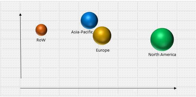
Asia-Pacific is observed to witness the fastest growth in the global geospatial imagery analytics market during the forecast period. A large number of internet users due to the increasing adoption of connected devices in the region, are providing ample growth opportunities for the growth of market in the region. Asia-Pacific is expected to account for over 50% of the worldwide internet population during the forecast period, according to a study published by Cisco Visual Networking Index (Cisco VNI).
Global Geospatial Imagery Analytics Market, By Region
Market Competitive Insight
Market players in the global geospatial imagery analytics industry are leveraging market growth through enhanced product portfolio, mergers and acquisitions, and successful distribution of requisite services to end-users. The key players operating in the geospatial imagery analytics market, such as ESRI, MDA Corp and DigitalGlobe Inc., are excessively investing in research and development for relatively longer time durations and are also performing mergers and acquisitions for robust dissemination in the market.
Some of the key players operating in the global geospatial imagery analytics market are :
- Satellite Imaging Corporation
- Hexagon AB
- DigitalGlobe
- Google Inc.
- UrtheCast Corporation Esri
- Fugro N.V.
- Harris Corporation
- Planet Labs
- Trimble
The Geospatial Imagery Analytics Market report offers a comprehensive market segmentation analysis along with an estimation for the forecast period 2026–2035.
Segments Covered in the Report
- By Type
- Video Analytics
- Image Analytics
- By Collection Medium
- Satellites, Geographic Information Systems (GIS)
- Unmanned Aerial Vehicles (UAVS)
- Others
- By Application
- Geospatial Data Acquisition and Mapping
- Surveillance and Monitoring
- Disaster Management
- Construction and Development
- Exhibition and Live Entertainment
- Energy and Resource Management
- Conservation and Research
- By Vertical
- Agriculture and Forestry
- Government
- Energy and Mining
- Civil Engineering and Archaeology
- Defense
- Healthcare and Lifescience
- Media and Entertainment
- Others
Region Covered in the Report
- North America
- U.S.
- Canada
- Mexico
- Europe
- Germany
- U.K.
- France
- Italy
- Spain
- Russia
- Rest of Europe
- Asia-Pacific (APAC)
- China
- Japan
- India
- South Korea
- Rest of Asia-Pacific
- Rest of the World (RoW)
- Brazil
- Saudi Arabia
- South Africa
- U.A.E.
- Other Countries
PRIMARY RESEARCH INTERVIEWS - BREAKDOWN
Source:VynZ Research
Frequently Asked Questions
Purchase Options
Latest Report
Research Methodology
- Desk Research / Pilot Interviews
- Build Market Size Model
- Research and Analysis
- Final Deliverable
Connect With Our Sales Team
- Toll-Free: 1 888 253 3960
- Phone: +91 9960 288 381
- Email: enquiry@vynzresearch.com
Geospatial Imagery Analytics Market